1. MAGNITUDE : 9.5
Chile; 12 May 1960

source : http://1.usa.gov/iJDMy
Casualties : Approx. 1,655
Injuries : 3,000
Homeless : 2 Million
Cost of Damage : US$550M
Affected Countries due to Tsunami:
Japan - 138 deaths and US$50M damage
Philippines - 32 dead and missing
USA West Coast - 61 deaths (Hawaii) and US$500,000 damage
Severe damage from shaking occurred in the Valdivia-Puerto Montt area. Most of the casualties and much of the damage was because of large tsunamis which caused damage along the coast of Chile from Lebu to Puerto Aisen and in many areas of the Pacific Ocean. Puerto Saavedra was completely destroyed by waves which reached heights of 11.5 m (38 ft) and carried remains of houses inland as much as 3 km (2 mi). Wave heights of 8 m (26 ft) caused much damage at Corral.
Tsunamis caused 61 deaths and severe damage in Hawaii, mostly at Hilo, where the runup height reached 10.6 m (35 ft). Waves as high as 5.5 m (18 ft) struck northern Honshu about 1 day after the quake, where it destroyed more than 1600 homes and left 185 people dead or missing. Another 32 people were dead or missing in the Philippines after the tsunami hit those islands. Damage also occurred on Easter Island, in the Samoa Islands and in California. One to 1.5 m (3-5 ft) of subsidence occurred along the Chilean coast from the south end of the Arauco Peninsula to Quellon on Chiloe Island. As much of 3 m (10 ft) of uplift occurred on Isla Guafo. Many landslides occurred in the Chilean Lake District from Lago Villarica to Lago Todos los Santos.
 |
| The calculated travel times (in hours) are shown for the tsunami produced by the 1960 Chile, earthquake. source : http://1.usa.gov/fTYSXe |
On May 24, Volcan Puyehue erupted, sending ash and steam as high as 6,000 m. The eruption continued for several weeks.
This quake was preceded by 4 foreshocks bigger than magnitude 7.0, including a magnitude 7.9 on May 21 that caused severe damage in the Concepcion area. Many aftershocks occurred, with 5 of magnitude 7.0 or greater through Nov 1.
This is the largest earthquake of the 20th Century. The rupture zone is estimated to be about 1000 km long, from Lebu to Puerto Aisen.
Note that the tsunami deaths from outside Chile are included in the 1,655 total. This is still considerably fewer than some estimates which were as high as 5,700. However, Rothe and others state that the initial reports were greatly overestimated. The death toll for this huge earthquake was less than it might have been because it it occurred in the middle of the afternoon, many of the structures had been built to be earthquake-resistant and the series of strong foreshocks had made the population wary.
2. MAGNITUDE : 9.2
Prince William Sound, Alaska; 12 May 1960

source : http://1.usa.gov/cqugRq
Casualties : 128 deaths (earthquake 15, tsunami 113)
Cost of Damage : US$311M
Affected Countries due to Tsunami: USA West Coast - 15 deaths
This great earthquake and ensuing tsunami took 128 lives (tsunami 113, earthquake 15), and caused about $311 million in property loss. Earthquake effects were heavy in many towns, including Anchorage, Chitina, Glennallen, Homer, Hope, Kasilof, Kenai, Kodiak, Moose Pass, Portage, Seldovia, Seward, Sterling, Valdez, Wasilla, and Whittier.
Anchorage, about 120 kilometers northwest of the epicenter, sustained the most severe damage to property. About 30 blocks of dwellings and commercial buildings were damaged or destroyed in the downtown area. The J.C. Penny Company building was damaged beyond repair; the Four Seasons apartment building, a new six-story structure, collapsed; and many other multistory buildings were damaged heavily. The schools in Anchorage were almost devastated. The Government Hill Grade School, sitting astride a huge landslide, was almost a total loss. Anchorage High School and Denali Grade School were damaged severely. Duration of the shock was estimated at 3 minutes.
 |
| Abridged from Seismicity of the United States, 1568-1989 (Revised), by Carl W. Stover and Jerry L. Coffman, U.S. Geological Survey Professional Paper 1527, United States Government Printing Office, Washington: 1993. source : http://1.usa.gov/f1PsJP |
Landslides in Anchorage caused heavy damage. Huge slides occurred in the downtown business section, at Government Hill, and at Turnagain Heights. The largest and most devastating landslide occurred at Turnagain Heights. An area of about 130 acres was devasted by displacements that broke the ground into many deranged blocks that were collapsed and tilted at all angles. This slide destroyed about 75 private houses. Water mains and gas, sewer, telephone, and electrical systems were disrupted throughout the area.
The earthquake was accompanied by vertical displacement over an area of about 520,000 square kilometers. The major area of uplift trended northeast from southern Kodiak Island to Price William Sound and trended east-west to the east of the sound. Vertical displacements ranged from about 11.5 meters of uplift to 2.3 meters of subsidence relative to sea level. Off the southwest end of Montague Island, there was absolute vertical displacement of about 13 - 15 meters. Uplift also occurred along the extreme southeast coast of Kodiak Island, Sitkalidak Island, and over part or all of Sitkinak Island. This zone of subsidence covered about 285,000 square kilometers, including the north and west parts of Prince William Sound, the west part of the Chugach Mountains, most of Kenai Peninsula, and almost all the Kodiak Island group.
This great earthquake was felt over a large area of Alaska and in parts of western Yukon Territory and British Columbia, Canada.
3. MAGNITUDE : 9.1
Off the West Coast of Northern Sumatra; 26 December 2004
Off the West Coast of Northern Sumatra; 26 December 2004
Casualties : 235,800 deaths (Indonesia)
Affected Countries :
Sri Lanka - 30,900 deaths
India - 10,700 deaths
Thailand - 5,300 deaths
Somalia - 150 deaths
Myanmar - 90 deaths
Maldives - 82 deaths
Malaysia - 68 deaths
Tanzania - 10 deaths
Seychelles - 3 deaths
Bangladesh - 2 deaths
Kenya - 1 death
Sri Lanka - 30,900 deaths
India - 10,700 deaths
Thailand - 5,300 deaths
Somalia - 150 deaths
Myanmar - 90 deaths
Maldives - 82 deaths
Malaysia - 68 deaths
Tanzania - 10 deaths
Seychelles - 3 deaths
Bangladesh - 2 deaths
Kenya - 1 death

The devastating earthquake of 26 December 2004 occurred as thrust-faulting on the interface of the India plate and the Burma plate. In a period of minutes, the faulting released elastic strains that had accumulated for centuries from ongoing subduction of the India plate beneath the overriding Burma plate.
In a broad sense, the India and Australian plates move toward the north- northeast with respect to the interior of the Eurasia plate with velocities of about 60 mm/y in the region of the earthquake. In the region of northern Sumatra and the Nicobar Islands, most of the relative motion of India/Australia and the Eurasia plate is accommodated at the Sunda trench and within several hundred kilometers to the east of the Sunda trench, on the boundaries of the Burma plate. The direction in which India/Australia converges toward Eurasia is oblique to the trend of the Sunda trench. The oblique motion is partitioned into thrust-faulting and strike-slip faulting. The thrust faulting occurs on the interface between the India plate and the western margin of the Burma plate and involves slip directed at a large angle to the orientation of the trench. The strike-slip faulting occurs on the eastern boundary of the Burma plate and involves slip directed approximately parallel to the trench. The 26 December main shock occurred as the result of thrust faulting on the western Burma-plate boundary, but many strike-slip faulting aftershocks occurred on the eastern plate boundary.
 |
| source : http://1.usa.gov/h5LIcW |
Currently available models of the 26 December main-shock fault displacement differ in many interesting details, but are consistent in implying that fault- rupture propagated to the northwest from the epicenter and that substantial fault-rupture occurred hundreds of kilometers northwest of the epicenter. The data upon which the modeling is based do not permit confident resolution of the extent of rupture beyond about 500 km northwest of the main-shock epicenter. The width of the earthquake rupture, measured perpendicular to the Sunda trench, is estimated to have been about 150 kilometers and the maximum displacement on the fault plane about 20 meters. The sea floor overlying the thrust fault would have been uplifted by several meters as a result of the earthquake.
The zone of aftershocks to the 26 December earthquake is over 1300 km long. Because aftershocks occur on and very near the fault-planes of main shocks, the length of the aftershock zone suggests that main-shock fault-rupture may have extended north of the epicenter by an amount significantly larger than 500 km. However, a great earthquake may also trigger earthquake activity on faults that are distinct from the main-shock fault plane and separated from it by tens or even hundreds of kilometers. We will not know until further analysis how much of the 26 December aftershock zone may correspond to activity in the immediate vicinity of the main-shock rupture, and how much may correspond to activity remote from the main-shock rupture.
4. MAGNITUDE : 9.0
Near the East Coast of Honshu, Japan; 11 March 2011
Casualties : estimated 10,000+

The magnitude 9.0 Tohoku earthquake on March 11, 2011, which occurred near the northeast coast of Honshu, Japan, resulted from thrust faulting on or near the subduction zone plate boundary between the Pacific and North America plates. At the latitude of this earthquake, the Pacific plate moves approximately westwards with respect to the North America plate at a rate of 83 mm/yr, and begins its westward descent beneath Japan at the Japan Trench. Note that some authors divide this region into several microplates that together define the relative motions between the larger Pacific, North America and Eurasia plates; these include the Okhotsk and Amur microplates that are respectively part of North America and Eurasia.
The location, depth, and focal mechanism of the March 11 earthquake are consistent with the event having occurred on the subduction zone plate boundary. Modeling of the rupture of this earthquake indicate that the fault moved upwards of 30-40 m, and slipped over an area approximately 300 km long (along-strike) by 150 km wide (in the down-dip direction). The rupture zone is roughly centered on the earthquake epicenter along-strike, while peak slips were up-dip of the hypocenter, towards the Japan Trench axis. The March 11 earthquake was preceded by a series of large foreshocks over the previous two days, beginning on March 9th with a M 7.2 event approximately 40 km from the epicenter of the March 11 earthquake, and continuing with another three earthquakes greater than M 6 on the same day.
The Japan Trench subduction zone has hosted nine events of magnitude 7 or greater since 1973. The largest of these, a M 7.8 earthquake approximately 260 km to the north of the March 11 epicenter, caused 3 fatalities and almost 700 injuries in December 1994. In June of 1978, a M 7.7 earthquake 35 km to the southwest of the March 11 epicenter caused 22 fatalities and over 400 injuries. Large offshore earthquakes have occurred in the same subduction zone in 1611, 1896 and 1933 that each produced devastating tsunami waves on the Sanriku coast of Pacific NE Japan. That coastline is particularly vulnerable to tsunami waves because it has many deep coastal embayments that amplify tsunami waves and cause great wave inundations. The M 7.6 subduction earthquake of 1896 created tsunami waves as high 38 m and a reported death toll of 27,000. The M 8.6 earthquake of March 2, 1933 produced tsunami waves as high as 29 m on the Sanriku coast and caused more than 3000 fatalities. Unlike the recent magnitude 9.0 earthquake, the 1933 earthquake did not occur as the result of thrust faulting on the subduction-zone plate interface, but rather within the Pacific plate just seaward of the Japan Trench.
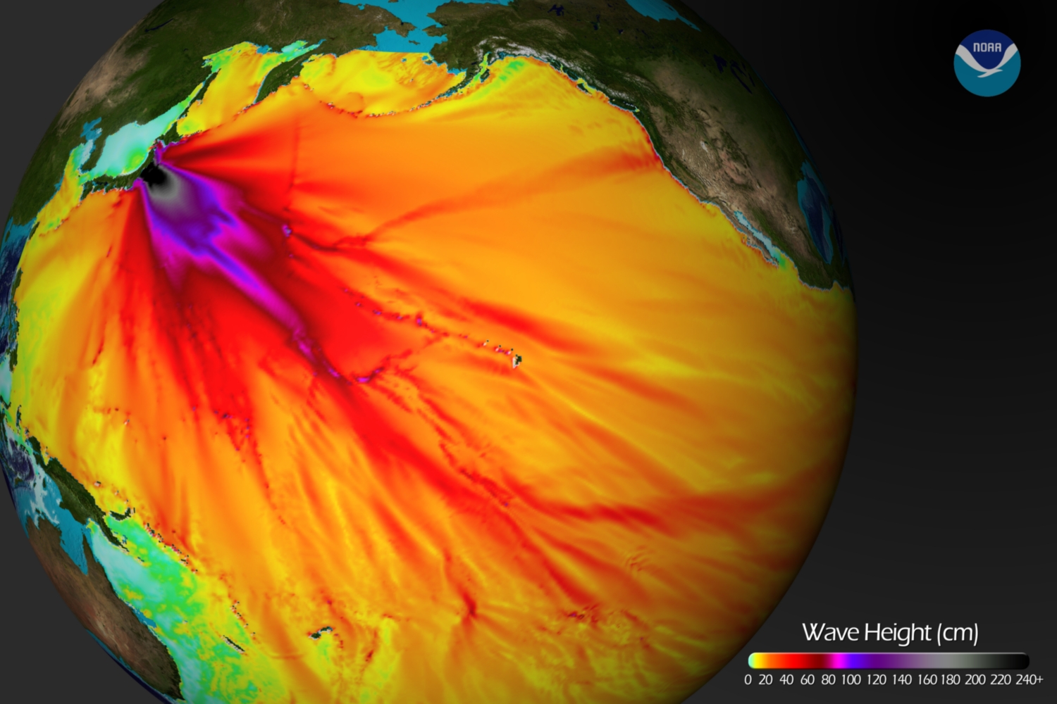 |
| Tsunami Wave Height source : http://bit.ly/fWqENd |
The March 11, 2011 earthquake far surpassed other post-1900 plate-boundary thrust-fault earthquakes in the southern Japan Trench, none of which attained M8. A predecessor may have occurred on July 13, 869, when the Sendai area was swept by a large tsunami that Japanese scientists have identified from written records and a sand sheet.
Continuing readjustments of stress and associated aftershocks are expected in the region of this earthquake. The exact location and timing of future aftershocks cannot be specified. Numbers of aftershocks will continue to be highest on and near to fault-segments on which rupture occurred at the time of the main-shock. The frequency of aftershocks will tend to decrease with elapsed time from the time of the main shock, but the general decrease of activity may be punctuated by episodes of higher aftershock activity. Beyond the ongoing aftershock sequence, the USGS does not believe that the earthquakes in Japan have significantly raised the probability of future major earthquakes. While the probability of future large earthquakes far from northern Honshu has not increased, neither has it decreased and large earthquakes will continue to occur just as we have observed in the past.
5. MAGNITUDE : 9.0
Kamchatka; 04 November 1952
Casualties : 0 death
Damage : US$800,000 - US$1M
 |
| source : http://1.usa.gov/eb8UQQ |
On November 4, 1952, at 16:52 GMT, an earthquake occurred off the coast of the Kamchatka Peninsula, Russia. A Pacific-wide tsunami was triggered by the earthquake, which had a surface-wave magnitude of 8.2, an epicenter of 52.8° N, 159.5° E, and a focal depth of 30 km. Six cows died and no human lives were lost in Hawaii where damage estimates ranged from $800,000- $1,000,000 (1952 dollars).
The tsunami had caused severe damage to Kamchatka Peninsula and then proceeded throughout the pacific. Midway Island was innundated with 1 m of water, flooding streets and buildings. On the Hawaiian Islands the waves destroyed boats, knocked down telephone lines, destroyed piers, scoured beaches, and flooded lawns. In Honolulu Harbor a cement barge was thrown into a freighter. In Hilo Bay a small bridge connecting Cocoanut Island to the shore was destroyed by a wave when it lifted off its foundation and then smashed down.
 |
| Aerial view of Kaika Bay near Haleiwa on the north shore of Oahu shows the fourth wave climbing up beach toward the beach houses and shows the extent of inundation from previous waves. Photograph Credit: George Curtis. source : http://bit.ly/i0ccvB |
At Cocoanut Island the water swept in with a run-up of 12 feet. It was observed in Hilo that the run-up could have been as high as 11 1/2 feet. Also in Hilo, at Reed's Bay, the water level rose as high as 11 feet. Hilo Bay recorded the highest levels of run-up. At most of the other coastal cities in Hawaii, the water rise was barely noticeable. During this event, the interesting observation was made that the highest or most destructive wave would vary from location to location. Without knowing which wave will be the largest at a particular location the local authorities must properly warn residents that could be affected and keep them away from the shore until it is safe to return.
via USGS
No comments:
Post a Comment